Open Geospatial Data in Constrained Environment
In this guest post by Tindak Malaysia volunteer: Danesh Prakash Chacko explains the nitty gritty on how the Electoral and Administrative Boundaries data set is made ready (with proper quality + citations) for the public reuse.
Sinar Project works in a constrained environment here in Malaysia. Open Data is not easily obtainable; and we get them only in disjointed bits and pieces.
One such category of data is Geospatial Data; however we are fortunate our partners Tindak Malaysia http://www.tindakmalaysia.org/ had produced these critical data sets. PY Wong and his group of volunteers had spent countless of hours hand tracing using QGIS Malaysia's Electoral and Administraive Boundaries.
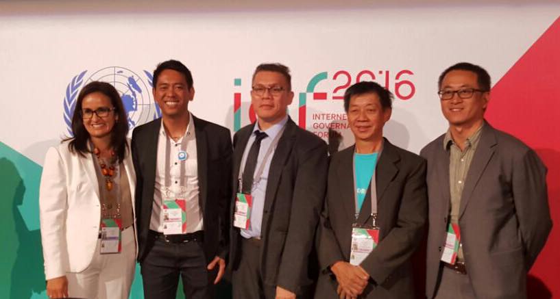
Firstly, congratulations to Tindak Malaysia for winning the recent ISIF Asia 2016 Technical Innovation Award and Community Choice Award 2016. Read more about it here.

Source: ISIF Asia. PY Wong - Lead (second from right)
In this guest post by Tindak Malaysia volunteer Danesh Prakash Chacko; GIS Expert based in Australia; explains the nitty gritty on how the Electoral and Administrative Boundaries data set is made ready (with proper quality + citations) for the public reuse.
All Geospatial data from Tindak Malaysia (and others) can be found at Sinar Project's CSO Data Portal. Just search with the keyword GIS like here.
Introduction
Open geospatial data is something in the Western World and some developing countries takes for granted. However, much spatial data in the developing world has been locked up under the veneer of secrecy and national security policies.
Such policies not only hinder the full realization of potential of geospatial data but creates opacity and suspicions on government policy. Moreover, copyright policies restrict the dissemination of the information in freely and useable format.
In Malaysia, due to lack of local council elections, citizens air their discontent of failure of public service to their elected State or Federal Representatives. However, citizens may not necessarily know the geographic coverage of their constituencies.
Tindak Malaysia is a dedicated NGO for electoral reform and voter empowerment. One of our significant works was to digitize all the electoral boundaries of Malaysia and present it on what could be Malaysia’s first ever Online Electoral Map Platform. However, the datasets were kept within the confines of the organization.
Sinar Project, a dedicated Malaysian group on open data and leveraging technologies for transparency, approached Tindak Malaysia to disclose the GIS data (electoral boundaries) through their Civil Society Open Data Portal.
Challenges and Process
Tindak Malaysia conducted significant discussions on disclosure policy of the datasets (assessing the risks). After getting internal approval from the leadership, Tindak Malaysia and Sinar Project agreed on the ownership and licensing terms of the datasets.
Secondly, the initial digitization of electoral boundaries wasn’t audited for long time and its attribute data wasn’t updated. Since the data will be disclosed for public consumption, it is imperative the datasets are accurate both in spatial and attribute terms.
Tindak Malaysia GIS Team is currently doing a rigorous dataset audit (conform to the GIS data standards) prior to release of the datasets in the Portal.
All the datasets disclosed by Tindak Malaysia has metadata which explicitly states the origin, disclaimers and appropriate scale to be used.
As Malaysia has 13 states and 3 territories, Tindak Malaysia electoral GIS Data is structured along 16 regions. The datasets are being released state by state and have been verified prior to release. As the moment of writing, 4 statewide datasets have been released.
In line of Open Data and GIS format standards, all the spatial datasets are released in GeoJSON format; and metadata are released in .csv format.
Tindak Malaysia GIS Team has ensured the uniformity of all the datasets (all the datasets would have the same set of fields and field types).
Hopefully, a single nationwide datasets will be made which unites all the 16 regions. This will feed into a different need for the audience who wants to see issue at national level, as opposed to state level.
Moving Forward
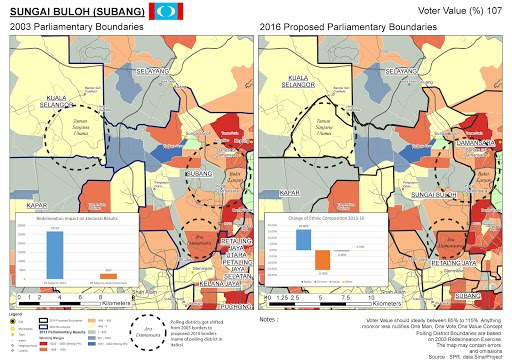
The datasets on administrative and electoral boundaries clearly highlights the unfair redistricting during the current first round of challenge against the Election Commission of Malaysia's Redelineation process.
Source: https://plus.google.com/+DaneshChacko/posts/dkBwxivb5GW
Another good example was during the Open Day Hackathon organized by Sinar in March which leveraged on Tindak GIS boundary data. The boundary data was utilized to assess the teacher to student ratios in Selangor.
In longer term, the disclosure of open spatial data in this portal will allow more collaborative sharing and push the Malaysian government to do likewise.
Resources
Tindak Malaysia Facebook Page - https://www.facebook.com/TindakActionMalaysia
Volunteer for Tindak Malaysia - http://www.tindakmalaysia.org
Tindak Malaysia Open Data Page - http://data.sinarproject.org/organization/tindak-malaysia
