
Geospatial Mapping and Satellite Computer Vision (CV) Modelling
Build a custom Python data pipeline to compile an independent, verifiable spatial registry of data centres across Malaysia
- Type
- Research and knowledge generation
- Status
- Closed
| Start Date | 2026-03-16 |
| End Date | 2026-09-15 |
Project Activity Details
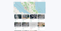
he pipeline utilised the Google Places API for precise geocoding, followed by a Computer Vision (CV) spatial extraction engine. High- resolution satellite images of the facilities were captured, and spatial bounding boxes were applied to extract the physical structural area (in square metres) of the facilities.
Resources

GSA Resource Security (Code)
20 October 2026 GSA Resource Security is an independent, satellite-derived audit of the physical resource footprint of data centre facilities in Malaysia: estimated power demand, energy consumption, water use, carbon emissions, and land-use/deforestation impact, cross-referenced against the regulatory and legislative record. Read More
20 October 2026 GSA Resource Security is an independent, satellite-derived audit of the physical resource footprint of data centre facilities in Malaysia: estimated power demand, energy consumption, water use, carbon emissions, and land-use/deforestation impact, cross-referenced against the regulatory and legislative record. Read More
Data Centers: Resouce Security
15 September 2026 An independently measured visual library of 71 data centre buildings in Malaysia — satellite-derived footprint, power, water, and carbon estimates. Read More
15 September 2026 An independently measured visual library of 71 data centre buildings in Malaysia — satellite-derived footprint, power, water, and carbon estimates. Read More
